Eastside

Athabasca Basin, Saskatchewan

Actual Picture of the Eastside Project

Overview

Focused Uranium Exploration in the Athabasca Basin

Eastside stands as a testament to the pioneering spirit and dedication of geological experts, under the leadership of Dr. Irvine R. Annesley, P.Geo. Dr. Annesley’s distinguished reputation as an academic leader within Saskatchewan’s REE and uranium industry underscores the calibre of individuals dedicated to this project’s success.

Eastside’s mission goes beyond resource exploration; it embodies a commitment to a cleaner, more sustainable future and the economic prosperity of Saskatchewan’s local communities. This endeavour ensures that Eastside’s uranium resources are harnessed for the benefit of all, contributing to a brighter and more eco-conscious world.

Project Location

Northern Saskatchewan

Click on a property to learn more

Location

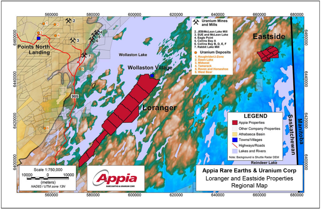
Eastside derives immense advantages from its strategic proximity to Cameco’s Rabbit Lake uranium mill and Eagle Point mine operations, situated approximately 28 kilometres west of Appia’s Eastside property. This advantageous location fosters operational synergy and resource optimization, contributing to the efficiency and success of exploration endeavours.

The Eastside project makes smart use of helicopter support, providing rapid and efficient access that enhances the overall productivity of our exploration and operational activities. This approach optimizes the ability to reach various key sites swiftly.

Situated near essential transportation infrastructure, Eastside enjoys year-round accessibility by both plane and ice road. This strategic location ensures that our operations can continue seamlessly throughout the year, offering logistical convenience and operational continuity.

Infrastructure

Click map to enlarge

Geology & Mineralization

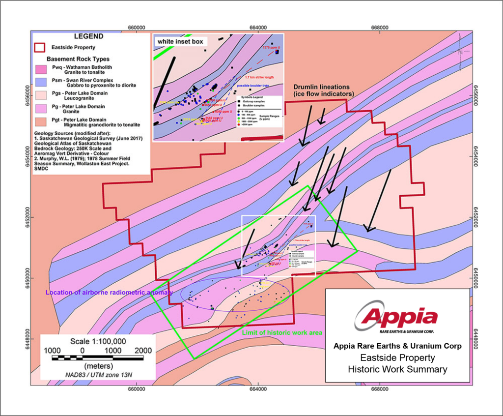
Nestled within the Archean-aged Peter Lake Domain, our property hosts platinum group elements (PGE) including gold, copper, and REE. This ancient domain has seen the discovery of various surface uranium occurrences. Picture a geologic tapestry showcasing a sequence of rocks: from the Paleoproterozoic Wathaman Batholith’s granitic intrusion of neoArchean gabbroic and dioritic lithologies, adorned with ultramafic rocks (the hornblende-rich ones are a favourite). Add to this Archean granodioritic to tonalitic migmatitic gneiss, a variety of younger granitoid rocks and gneisses, all intruded by Pegmatite weaving through this canvas. Notably, the presence of Uranium-Thoruim-REE-rich pegmatites echoes the signature of sub-Athabasca high-grade basement-hosted uranium deposits. Our property, situated about 85 km east of the Athabasca Basin margin, defies convention by embracing a near-surface uranium deposit model. Hosted by pegmatites, the uranium mineralization discovered to date doesn’t rely on Athabasca Basin cover.

Airborne radiometric surveys uncovered radioactive boulders, till, and outcrop across our property. Ground prospecting and sampling revealed uranium concentrations ranging from 2 to 7,575 ppm, with an average grade of 360 ppm uranium. Notably, twelve samples exceeded 1,000 ppm uranium.

Exploring a 1.7 km geological strike, three outcrop samples showed uranium concentrations of 2,538 ppm, 6,650 ppm, and 7,575 ppm. Additionally, five boulders, sharing lithological characteristics with the outcrops and strategically located down-ice, returned uranium levels surpassing 1,000 ppm.

The standout performers are boulders sourced from hornblende-bearing pegmatites within hornblende-rich felsic gneisses, presenting an intriguing opportunity for further exploration and potential discoveries.
Click map to enlarge

Exploration

Embarking on the journey of discovery at Eastside is a dynamic process powered by a sophisticated complement of advanced exploration tools and expertise, acting as a toolkit, leading us toward mineral findings and innovative insights.

In the initial stages of mineral exploration, the pivotal roles of field reconnaissance and prospecting, enable the gathering of crucial geological data. Field reconnaissance initiates as a preliminary phase, where our skilled geologists and exploration teams conduct a thorough visual inspection of the terrain. This involves mapping geological formations, capturing detailed photographs, and collecting basic rock and soil samples for initial analysis, laying the groundwork for a foundational understanding of the geological setting.

Transitioning into prospecting, a more detailed and systematic exploration unfolds. Our geologists hone in on specific areas exhibiting signs of potential mineralization. This entails systematic sampling, deploying geophysical surveys to detect subsurface anomalies, and conducting geochemical surveys to analyze soil and rock samples for their composition. Additionally, trenching may be employed to expose subsurface geology. The overarching goal remains to identify areas with economic mineral deposits.

Both field reconnaissance and prospecting stand as integral steps in the exploration process, not only aiding in pinpointing potential targets but also providing valuable data for subsequent exploration phases. The insights garnered from these activities serve as a guiding force for our ongoing exploration efforts, allowing us to prioritize areas for more in-depth study in our continual quest to discover and understand mineral resources.

Learn More About Our Eastside Project

Get a more in-depth look at our maps, reports, exploration charts, historical work and data. We provide everything you’ll need to become well educated on our projects

Project News

Appia Begins Uranium Exploration Season With Ground Reconnaissance at “EASTSIDE” Project SASKATCHEWAN, CANADA

Appia Samples over 65 Metres of Continuous Uranium Mineralization at Surface on the Eastside Property and Identifies Ree-Bearing Pegmatite on the Loranger Property

Appia Identifies Multiple Radiometric Anomalies on Eastside Property, Athabasca Basin

Subscribe